WMS Browser 3.9
Copyright by Tom Vijlbrief, November 2006.
Email: tomtor at xs4all.nl
Web: http://www.v7f.eu
This program is a WMS client/browser with GPS support for Java J2ME MIDP2 phones or PDA devices and
it is free to use for non commercial purposes.
It features:
- Tracks
- Waypoints with audio alarm
- Points of Interest with audio alarm (handy for speed cameras)
- Maps from local storage
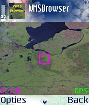
A Nokia 6680 screendump with GPS location
(note that
the browser also features a full screen mode
which leaves more room for the map):
The program has a help-screen. It explains the most important navigation keys:
Use the arrows or

1 2 3
4   6
7 8 9

fire/5: zoom-in
0:      zoom-out
*/#:    zoom-factor

soft key: exit map view
You can add maps from various sources. Look at this overview for a list of public WMS servers. Note that you should be able to find interesting servers for your location at other places as well. Google is your friend.
First copy the demo entry with the 'clone' command. (This is not really needed but is is handy to maintain the demo entry as a working start point). You can always use the 'Reset to defaults' command to restore the original configuration, but you will loose all your server definitions!
Select the new entry and change the base-URL so that it points at another WMS-server. You can adapt the X, Y, center and span options at this point but it is easier to navigate to the correct place on earth in the Map view. You should adapt the span values if the image is distorted for the place on earth you are looking at.
Note that WMSBrowser stores all your changes, including the location you navigated to on your maps!
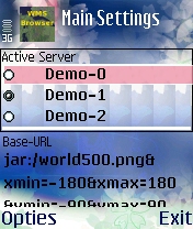
It is also possible to use small built-in maps that are stored in the .jar file. Demo-1 is an example of that. This saves you network costs. You can add your own map if you like. These small maps are also handy to use as a static background for your hiking activities, when you use the waypoint and track features of WMSBrowser.
Another option is to load files from memory card, but the size is limited by the internal memory of your phone. Use e.g.:
file:///E:/world500.png&xmin=-180&xmax=180&ymin=-90&ymax=90to load it from the E: drive of a Nokia phone. A problem with Nokia's is that the phone will ask if it is ok to read the data on every access.
You can solve this by installing my certificate and then installing with the .jad.
Since version 3.3 is it possible to read LARGE FILES FROM YOUR MEMORY CARD, but it MUST be a PNG (non-interlaced) with 256 or 16 colors, e.g.:
png:///E:/world500.png&xmin=-180&xmax=180&ymin=-90&ymax=90Note the "png:" prefix instead of "file:" or "jar:". So you specify the lat long boundaries of the image after the file location as xmin (is long min), xmax (is long max), etc.
Note that a reasonable file size is about 1 or 2 megabytes, depending on the speed of your phone.
A good approach is to use a WMS server and to save the image file with your browser. The WMS request has bbox parameters and you should use these values for xmin,xmax,... E.g.:
    http://terraserver.microsoft.com/ogcmap6.ashx?version=1.1.1&request=GetMap&Layers=DRG&
      Styles=&SRS=EPSG:4326&BBOX=-90,40,-89,41&width=1000&height=800&format=image/jpeg
Note that most WMS servers use "image/png" instead of jpeg.
With ImageMagick you can convert the file to 16 colors (and remove interlacing):
convert -colors 16 org.jpg usgs.png
Now you can use the following definition in WMSBrowser:
png:///E:/usgs.png&xmin=-90&ymin=40&xmax=-89&&ymax=41
Suggestions for maps would be nice!
Options
The 'Options' screen allows you to disable full-screen map mode,
change the map cache
size, change metric mode (miles/feets or km/meters) and the options for GPS usage!
Note that tracking will only work after you switched GPS on in this screen.
In the current version you can also save your waypoints and tracks to memory card!
You specify the root and two csv files will be written: "wms_tr.csv" and "wms_wp.csv".
The old version is still available for devices that get confused by the bluetooth
code.
Bluetooth GPS
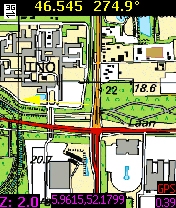
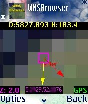
Activating the bluetooth GPS mode will position the map on your current position.
A small purple square shows the current position. If you move near the edges, then the map will be reloaded.
When GPS-mode is active the letters "GPS" are shown on the map.
Red letters mean the GPS-mode was selected but a bluetooth GPS-device could
not be found.
Yellow means bluetooth is ok, but a GPS-device was not yet found.
If the bluetooth search does not find a device, then it will turn red again.
If everything is ok then the letters will turn green. Note that it
will turn yellow
when your GPS-device looses sight of the satellites.
The "GPS..." command shows you the info of your GPS-device:

The title of the GPS table shows the connection status of your GPS. The "Info..." command can be used for trouble shooting your GPS bluetooth connection. You can also restart the search of a GPS device from this screen.
Since version 3.8 WMSBrowser can use built-in GPS receivers as well.
Waypoints
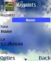
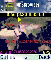
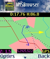
Waypoints can be added and navigated to (map display shows distance/heading, a yellow direction vector and a red vector which show the actual course). They are also displayed on the map. The default location for new waypoints is your current GPS position or the center of your current map display.
The waypoint screen shows you also the distance and bearing (relative to current position) of selected waypoints.
Since version 3.5 a sunrise/sunset calculator is available on this screen. The twilight time shown occurs twice a day: before sunrise and after sunset. If the sun does not rise, then it is the time before and after the brightest moment of the day. If the sun does not set, then the sunrise time is the time when the sun is at the highest point.
Version 3.6 features an alarm which is played when a waypoint is within a specified distance.
Tracks
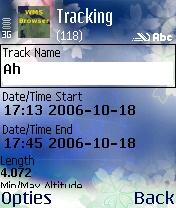
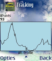
Tracks can be recorded.
The info stored is the track-length, start and end time, #points, min/max/avg velocity and height. Tracks and waypoints can be given a name. The default name is the creation time.
Two tracks are shown on your map. The current track (in green) and the selected track (in blue).
Points of Interest (POIs)
A sample POI file is provided in the .jar.
You can load POIs from a .csv file on your memory-card. The .csv file should have 4 comma separated columns: long, lat, name and description. Example:
    5.1,52.3,Some Place,A location in the Netherlands
    -70,0,Hot,A place on the equator
The alarm distance which you set in the WayPoint screen is valid for
all POIs! Note that WMSBrowser will only sound the alarm for POIs
which are within a few miles/kilometers.
Learn more about WMS web mapping.
Future plans:
- Add support for internal GPS devices. (Available in 3.8!)
- Add support for large maps from memory-card. (available for PGN since 3.3!)
- Fancy tracking reports/graphs (height profile IS in last version!)
- Sun/moon up/down calculator (since 3.5 Sun-calculator available)
- Google maps
- ...
Have fun! (PS, if you like the program, e-mail me with suggestions or
make
a donation with CreditCard/PayPal on
http://www.v7f.eu.)